Some
amazing pictures of a tornado have been doing the rounds. According to the info that accompanies them, these are "Photos of storm near Bunbury" (which is in Australia), although the text also notes that "you'd swear these
were taken in america's mid west / tornado belt..." This has started some discussion on
alt.folklore.urban, as people try to locate exactly where these photos were taken. The scenery does look a lot like the midwest.


Comments
Ok, that's definitely not in scientific terms, but that's the way I understand it. Someone else is free to correct anything in there that is wrong, or explain it better.
The point though, is that the corealis effect should have no effect on something like water in a toilet.
http://www.westernangler.com.au/forum/Storm_Photos/m_65768/tm.htm
It also includes what appear to be photographs of the aftermath. Being Australian, the forum participants can't express themselves very well, and so it's not really helpful. We'll have to wait until Snopes gets holds of this to know for sure.
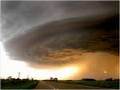
http://extremeinstability.com/2004photos.htm
😊
I debated these photos last night, through knowing the south west region very well, this is definately not the landscape or cloud formations seen in even the worst storms. The road aggregate colour, lack of fencing, yellow road line, road sign, housing style, driving side, and most of all crops (what appear to be fence-less corn and pineapples crops!!!) All pointing to bullshit 😊
We certainly did have a huge tornado here on Monday 16th May - and it did cause a lot of damage - including moving a cathedral off its foundations. The pictures you can see of house, business damage are definately real - I can give street addresses for these.
The pictures of the "actual" tornado ?? I don't believe these are local - for a start it was pitch dark (6.10 am) when it hit - and is only recorded as being 100m across but it did 'hit' a swath of damage along a 10Km 'stretch'. The "landscape" in those photo's is totally strange to me !!.
And looking at this week's forecast, I'll believe it - no rain predicted until this time next week!
I put them together on a site so you can see the real storm...
http://www.t00l.net/storm/
http://ww2010.atmos.uiuc.edu/(Gh)/guides/mtr/fw/crls.rxml
and here's another one:
http://www.usatoday.com/weather/resources/basics/coriolis-understanding.htm
there's a whole bunch by just googling "coriolis effect"
It's caused by a deflection process by the earth's rotation. Are you maybe thinking of tides?
Kangaroos generally don't roam the streets of Australia.
Sydney is not the capital
The water spins in the opposite direction in Australia as it drains from sinks and toilets.
http://extremeinstability.com/2004photos.htm
I do agree that the above pictures are strange as I can not recognise any scenery.
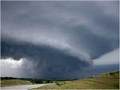
one of these photos have a paddock and in the paddock is a nice big green crop of something. in bunbury we are not in the growing season yet and we are just about to seed which means put the seed in the ground now this crop in the photo looks like its ready to be harvested people dont believe these photos. bunbury is not like these at all
- Lack of Australian scenery, in particular, gum trees
- American style barn with flagpole in frame 7
- reverse cyclonic rotation in the wall clouds and tornado (i.e., northern hemisphere) frames 3,4 and 8
- approaching car appears to be on wrong side of road in frame 2
- incorrect storm type, instead of a spring/summer supercell should have been a winter frontal system 〈cloud in frame 6 would be plausible if not for the scenery〉
I am familiar with the countryside near Bunbury and it is mostly well forested with hills in the distance, Tuart trees are a frequent large gum in the area, with plenty of Marri/Jarrah forest around. The flat coastal areas tend to peppermint and paperbark swamps. Bunbury itself is a reasonable sized city with a hill in the middle of it that you can see for miles around.
http://extremeinstability.com/2004photos.htm
Vehicles on the right side of the road
The street sign
The corn and soy bean crops
And it's flatter than $#@!
I'm moving back to Montana!
As I said back in May.......
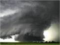
"Bleeding heck, how many more times do we have to post this: The storm photos are a hoax--they are from the collection of 2004 storm photos on the Extreme Instability site. They were in Iowa, USA, not Bunbury, and can be seen in their original state here:
http://extremeinstability.com/2004photos.htm
Posted by shel on Wed May 25, 2005 at 08:37 AM"
_We_ haven't been had, _we_ know where they're from.
Shel.
*shrugs*
Not only have these photographs been incorrectly circulated as a hoax under this name it has under other names as well unfortunately. And in one known case, it may have been submitted to one of the US channels incorrectly authored by someone in Texas. Mike Hollingshead has had to unfortunately come to terms with losing control of an absolutely awesome set of photographs.
Last Friday (Aug 18) a severe storm came through the Toronto area. We don't usually get storms that bad, so everyone was really impressed.
It took exactly 1 week for these photos to show up in my inbox with the caption, "Photos taken near Orangeville during last Friday's storm! Isn't nature amazing!?!" (Orangeville is in a rural area NW of Toronto.)
Where will they appear next? Anywhere but Iowa, no doubt.